Shaping of the Earth’s Surface Class 9 Question Answer SST Chapter 2
Practice with and Class 9 Social Science SST Chapter 2 Shaping of the Earth’s Surface Question Answer NCERT Solutions to improve your exam performance.
Class 9 SST Chapter 2 Shaping of the Earth’s Surface Question Answer
Class 9 Shaping of the Earth’s Surface Question Answer
The Big Questions (Page No. 13)
Question 1.
What shapes the Earth’s surface?
Answer:
The Earth’s surface is continuously shaped and reshaped by the combined action of internal (endogenic) forces and external (exogenic) forces. Internal forces originate deep inside the Earth and are responsible for creating major landforms. Processes such as volcanic eruptions, earthquakes, folding, and faulting can uplift or deform the Earth’s crust, leading to the formation of mountains, plateaus, and valleys. These forces often act suddenly but may also operate slowly over millions of years.
External forces act on Earth’s surface and gradually modify the landforms formed by internal forces. These include weathering, erosion, transportation, and deposition carried out by rivers, glaciers, wind, sea waves, and groundwater. For example, rivers carve valleys and gorges, wind forms dunes, and sea waves shape coastlines. Thus, the Earth’s surface is the result of a continuous interaction between constructive and destructive forces.
Question 2.
What is plate tectonics? What are the effects of plate movement?
Answer:
Plate tectonics is a scientific theory that explains how the Earth’s outer layer, called the lithosphere, is divided into several large and small tectonic plates. These plates float and move slowly over the semi-molten asthenosphere beneath them due to convection currents in the mantle.
The movement of tectonic plates has several important effects:
- Formation of fold mountains such as the Himalayas.
- Occurrence of earthquakes along plate boundaries.
- Formation of volcanoes when magma rises to the surface.
- Creation of ocean basins and mid-ocean ridges.
- Changes in the position of continents and oceans over time.
Although plate movements are very slow, they have shaped the Earth over millions of years and continue to influence natural events today. Understanding plate tectonics helps us identify earthquake-prone and volcanic regions and improve disaster preparedness.
Question 3.
How are landforms formed and how are they classified?
Answer:
Landforms are natural features found on the Earth’s surface. They are formed through various geological processes such as tectonic activity, weathering, erosion, transportation, and deposition.
Some landforms are created by internal forces. For example:
- Mountains are formed by plate collisions.
- Volcanoes are formed when magma reaches the Earth’s surface.
Other landforms are formed by external forces:
- Rivers create waterfalls, meanders, and deltas.
- Waves create beaches, sea cliffs, and sea arches.
- Glaciers form U-shaped valleys and moraines.
- Wind forms dunes and yardangs.
- Underground water creates caves and sinkholes.
Landforms are formed by internal forces such as plate tectonics and by external processes such as weathering, erosion, transportation, and deposition carried by rivers, glaciers, wind, waves and underground water. This classification helps geographers understand the processes responsible for shaping the Earth’s surface.
Question 4.
How are humans and other living beings connected to these landforms?
Answer:
Landforms influence the lives of humans, plants, and animals in many ways. They determine climate, vegetation, water availability, and settlement patterns. Fertile plains support agriculture and dense populations, while mountains provide forests, minerals, and river sources. Coastal areas support fishing and trade activities. Different plants and animals are adapted to specific landforms and environmental conditions. Human occupations, culture, transportation, and economic activities are also influenced by the surrounding landscape. Thus, landforms provide resources, habitats, and opportunities essential for the survival and development of all living beings.
Question 5.
How do disasters associated with different landforms impact human lives?
Answer:
Different landforms are associated with specific natural disasters that can significantly affect human life and property.
Mountain regions may experience landslides, avalanches, and Glacial Lake Outburst Floods. (GLOFs). These disasters can destroy roads, bridges, houses, and agricultural land, causing loss of life and disrupting communication.
Earthquake-prone regions may suffer severe damage to buildings and infrastructure due to tectonic activity. Coastal regions can face erosion and flooding, while arid regions may experience dust storms that affect agriculture and health.
These disasters not only cause immediate destruction but also affect livelihoods, education, transportation, and economic development. However, understanding landforms and the processes that shape them helps governments and communities plan better, reduce risks, and protect lives through disaster management and sustainable development practices.

Shaping of the Earth’s Surface Question Answer Class 9
InText Questions
Let’s Map
Question 1.
Pick any two plates from the map below and complete the table given below. (Page No. 16)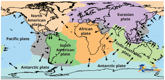

Answer:
| Name of the Plate | Continents | Ocean |
| Indo-Australian Plate | Australia and parts of Asia (including India) | Indian Ocean |
| South American Plate | South America | Atlantic Ocean |
Let’s Explore
Question 1.
Examine the plate map given above with the earthquake and volcano map given below. What correlation do you observe? (Page No. 16)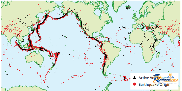
Answer:
After comparing the two maps, we observe that most earthquakes and volcanoes are concentrated along tectonic plate boundaries. Areas where plates meet are highly active because the movement of plates causes stress, friction, and the release of energy.
For example:
(i) The Pacific Ring of Fire has a large number of volcanoes and earthquakes.
(if) Regions near convergent and transform plate boundaries experience frequent seismic activity.
(iii) Very few earthquakes and volcanoes occur in the stable interior regions of plates.
This correlation shows that tectonic plate movement is the main cause of earthquakes and volcanic eruptions. The maps clearly demonstrate that plate boundaries are the most active geological zones on Earth.
Question 2.
Observe the map showing the distribution of earthquakes and volcanoes (Figure). Can you identify which continents and countries are located around the Ring of Fire with the help of an atlas or a globe? (Page No. 17)
Answer:
The Ring of Fire is a belt of active volcanoes and earthquake-prone regions surrounding the Pacific Ocean. It includes parts of the continents of Asia, North America, South America, and Australia (Oceania). Some important countries located around the Ring of Fire are: Japan, Indonesia, Philippines, New Zealand, Papua New Guinea, Russia (eastern part), United States of America (Alaska and western coast), Canada, Mexico, Guatemala, Chile, Peru, and Ecuador.
Question 3.
Does India have a risk of earthquakes?
India has experienced some major earthquakes in the past, resulting in thousands of deaths. A large earthquake in a densely populated country like India can cause severe damage to life and the environment. (Page 17)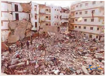
Figure: The extensive damage caused by the major earthquake in Gujarat in 2001
Can you find out which region is more vulnerable to earthquakes? Why do you think human lives are at risk?
Answer:
Yes, India is highly vulnerable to earthquakes because it is located near active tectonic plate boundaries. The Indian Plate is continuously moving northward and colliding with the Eurasian Plate, which has led to the formation of the Himalayas and continues to generate seismic activity.
The regions that are most vulnerable to earthquakes include the Himalayan region (Jammu and Kashmir, Himachal Pradesh, Uttarakhand), the North-Eastern states, parts of Bihar, the Kutch region of Gujarat, and the Andaman and Nicobar Islands. These regions are more vulnerable because of the movement and collision of the Indian plate with Eurasian plate.
Human lives are at risk because strong earthquakes can cause the collapse of buildings, bridges, roads, schools, and hospitals. In densely populated areas, a large number of people may be injured or killed. Earthquakes can also trigger landslides, fires, and damage to communication and transport networks, disrupting normal life and causing significant economic and environmental losses. Therefore, understanding earthquake-prone regions and adopting proper disaster preparedness measures are essential for reducing risks and protecting lives.
Question 4.
Look carefully at this photograph and answer the following questions:”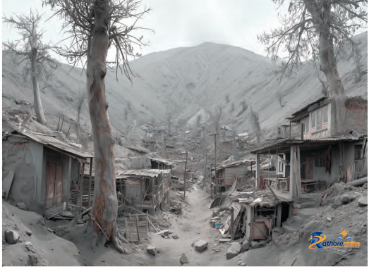
(i) What do you think caused this situation?
(ii) What could that grey powder be?
(iii) What does it tell us about the Earth’s internal forces? (Page No. 18)
Answer:
(i) This situation appears to have been caused by a volcanic eruption. The eruption released large amounts of ash and other volcanic materials, which settled over the surrounding area, covering houses, trees, and roads.
(ii) The grey powder is volcanic ash. It consists of fine particles of rock, minerals, and volcanic glass that are ejected into the atmosphere during a volcanic eruption and later deposited on the ground and objects.
(iii) The photograph shows that powerful forces are continuously active inside the Earth. Heat and pressure within the Earth’s interior can force magma, gases, and ash to the surface through volcanic eruptions. These internal forces have the ability to reshape landscapes, create new landforms, and sometimes cause widespread damage to human settlements. The image highlights how the Earth’s interior remains dynamic and plays an important role in shaping the Earth’s surface.
Question 5.
Observe the photographs given below and also note the types of erosion. How are farmers affected by erosion due to water and wind? (Page No. 21)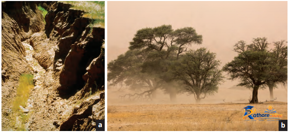
Figure. Erosion caused by (a) water and (b) wind
Answer:
Types of erosion shown in the photographs:
- Water erosion – Flowing water wears away and carries fertile topsoil, forming gullies and channels.
- Wind erosion – Strong winds remove loose and dry topsoil, especially in arid and semi-arid regions.
Water and wind erosion remove the fertile topsoil needed for crop growth, reducing soil fertility and lowering agricultural yields. Water erosion can wash away soil and crops, while wind erosion blows away fine soil particles from fields. As a result, farming becomes less productive, and farmers face difficulties in growing healthy crops.
Question 6.
Have you heard about the Sundarbans delta? Try to explore its uniqueness and find out why it is popular with tourists. (Page No. 25)
Answer:
The Sundarbans Delta is the world’s Ingest delta, formed by the rivers Ganga, Brahmaputra, and Meghna before they flow into the Bay of Bengal. It is spread across parts of India and Bangladesh and is famous for its vast network of rivers, distributaries, tidal creeks, mudflats, and islands. The most unique feature of the Sundarbans is its extensive mangrove forests. It is one of the largest mangrove forests in the world. These forests are specially adapted to survive in salty and waterlogged conditions. The region is also a UNESCO World Heritage Site and is known for its rich biodiversity. It provides habitat to many species of animals, including the famous Royal Bengal Tiger, estuarine crocodiles, spotted deer, fishing cats, and numerous species of birds and aquatic life.
The Sundarbans is popular with tourists because of its unique natural beauty, dense mangrove forests, winding waterways, and diverse wildlife. Visitors are attracted by boat safaris, birdwatching, wildlife photography, and the opportunity to observe the Royal Bengal Tiger in its natural habitat. The delta also plays an important role in protecting coastal areas from cyclones and tidal waves, making it an ecologically significant region. Thus, the Sundarbans Delta is unique not only because it is the largest delta in the world but also because of its rich biodiversity, mangrove ecosystem, and importance for both nature conservation and tourism.
Question 7.
Observe the landforms around your school or residence and try to identify which agent may have created them. (Page No. 32)
Answer:
The sudden flood in Chamoli, Uttarakhand, occurred because
- A large rock and ice mass broke off from a mountain.
- It triggered an avalanche and released huge amounts of water.
- The flood rushed through river valleys, destroying bridges, roads, hydro projects, and villages.
- Climate change and rapid glacier melting increased the risk of such disasters.
Question 8.
Complete the exercises given below for each type of disaster with the help of newspapers, atlases, and books. Make a list of disaster-prone areas from India and the world and enlist mitigation measures, quoting recent examples. (Page No. 32-36)
1. Landslides: prone areas, mitigation measures, and recent examples
2. Avalanches: prone areas, mitigation measures and recent examples
3. GLOFs: prone areas, mitigation measures and recent examples
4. Dust Storms: prone areas, mitigation measures and recent examples
Answer:
| Disaster | Prone Areas | Mitigation Measures | Recent Examples |
| Landslides | Jammu & Kashmir, Himachal Pradesh, Uttarakhand, Sikkim, Arunachal Pradesh, Kerala (Western Ghats) | Afforestation; avoid construction on unstable slopes; construct retaining walls and proper drainage systems; follow landslide early warning systems; regulate quarrying and deforestation. | Wayanad Landslides, Kerala (2024); Himachal Pradesh landslides during the monsoon (2025). |
| Avalanches | Ladakh, Jammu & Kashmir, Himachal Pradesh, Uttarakhand, Sikkim | Avalanche forecasting and early warning systems; avoid travel during heavy snowfall; construct avalanche barriers; monitor weather conditions; create public awareness. | Mana Avalanche, Uttarakhand (2025); Avalanches in Ladakh during winter (2025). |
| GLOFs (Glacial Lake Outburst Floods) | Sikkim, Uttarakhand, Himachal Pradesh, Arunachal Pradesh, Ladakh | Monitor glacial lakes; install early warning systems; strengthen embankments; prepare evacuation plans; promote climate-resilient development. | South Lhonak Lake GLOF, Sikkim (2023); Floods caused by glacial lake breaches in the Himalayan region (recent years). |
| Dust
Storms | Rajasthan (Thar Desert), Gujarat, Haryana, Punjab, Western Uttar Pradesh | Plant shelter belts; prevent overgrazing; practise soil conservation; promote sustainable farming; follow weather advisories and early warning systems. | Dust storms in Rajasthan and north-western India (2025); Dust storms affecting Delhi-NCR during summer (2025). |
Think about it
Question 1.
A devastating flood struck the Chamoli district in Uttarakhand in February 2021, in which many people and livestock lost their lives. There was severe damage to buildings, roads, bridges, and hydro projects, and connectivity to villages was adversely affected. Can you find out the reasons that led to the sudden and unexpected flood? (Page No. 29)
Answer:
The sudden and unexpected flood was caused by:
- The collapse of a large mass of rock and ice from a Himalayan mountain slope.
- A sudden surge of water and debris into the Rishiganga and Dhauliganga rivers.
- The steep mountainous terrain, which increased the speed and force of the flood.
Shaping of the Earth’s Surface Class 9 Questions and Answers
Questions and Activities (Page No. 37-38)
Question 1.
What are the sources of energy that are required to cause movements associated with the internal forces of the Earth?
Answer:
The internal forces of the Earth are powered mainly by two sources of energy:
- Heat from Earth’s interior
- The Earth’s core produces immense heat.
- This heat drives convection currents in the mantle, which push and pull tectonic plates.
- These movements cause earthquakes, volcanoes, folding, and faulting.
- Radioactive decay of elements
- Elements like uranium, thorium, and potassium break down deep inside the Earth.
- This process releases heat continuously, sustaining mantle convection over geological timescales.
Question 2.
Relate various physiographic divisions you have studied in the earlier grades with various endogenic forces responsible for their origin.
Answer:
| Physiographic Division | Endogenic Force Responsible |
| Himalayas | Folding due to collision of tectonic plates |
| Block Mountains and Rift Valleys | Faulting |
| Deccan Plateau | Volcanic activity |
| Volcanoes and Volcanic Islands | Volcanic eruptions |
| Mountain Ranges | Plate movements and folding |
| Earthquake-prone regions | Tectonic plate movements |
These landforms were formed due to internal forces such as folding, faulting, volcanic activity, and plate tectonics.
Question 3.
Why and where do earthquakes occur frequently? Is it possible to predict earthquakes?
Answer:
Earthquakes occur frequently because of the sudden release of energy when tectonic plates move, collide, separate, or slide past one another. They mainly occur along plate boundaries, especially around the Pacific Ring of Fire, the Himalayan region, and other tectonically active zones. At present, earthquakes cannot be predicted accurately in terms of exact time and location, although scientists can identify earthquake-prone regions and monitor seismic activity.
Question 4.
“Plate movements are responsible for the distribution of earthquakes and volcanoes.” Explain.
Answer:
Most earthquakes and volcanoes occur along tectonic plate boundaries. When plates collide, diverge, or slide past each other, stress builds up and is released in the form of earthquakes. At convergent and divergent boundaries, magma may rise to the surface, causing volcanic eruptions. Therefore, the distribution of earthquakes and volcanoes closely follows the pattern of tectonic plate boundaries, especially around the Pacific Ring of Fire.
Question 5.
Draw and label a diagram of a meander and a delta.
Answer:
Do it yourself.
Question 6.
How are deforestation and erosion associated with each other? Explain.
Answer:
Deforestation and erosion are closely related because trees play an important role in protecting the soil. The roots of trees hold the soil firmly in place, while their leaves reduce the impact of heavy rainfall. When forests are cut down, the soil becomes loose and exposed to rain, wind, and flowing water. During heavy rainfall, water easily washes away the fertile topsoil from deforested areas. Similarly, in dry regions, strong winds carry away the loose soil, causing wind erosion. As a result, the land loses its fertility, making farming difficult and reducing crop production.
Deforestation also increases the chances of landslides in hilly areas because tree roots no longer support the slopes. Rivers receive large amounts of eroded soil, leading to siltation and increasing the risk of floods. To reduce erosion, forests should be protected, more trees should be planted, and sustainable farming practices such as contour ploughing, terracing, and bunding should be encouraged. Thus, deforestation directly increases soil erosion and harms agriculture, biodiversity, and the environment.
Question 7.
Develop a plan to protect the land in your local area from erosion.
Answer:
A plan to protect land from erosion may include:
- Plant more trees and grasses to bind the soil.
- Prevent deforestation and overgrazing.
- Construct contour trenches and bunds on slopes.
- Promote terracing in hilly areas.
- Build check dams to reduce the speed of flowing water.
- Encourage sustainable farming practices.
- Create awareness among local people about soil conservation.
- Maintain proper drainage systems to prevent waterlogging and runoff.
These measures help conserve soil and reduce erosion effectively.
Question 8.
Which disasters do you think you might experience in your region? Discuss a mitigation plan in your classroom.
Answer:
The disasters that may occur in my region include earthquakes, floods, landslides (in hilly areas), and dust storms, depending on the local geographical conditions.
Mitigation Plan:
- Spread awareness about disaster preparedness and safety measures.
- Plant more trees and prevent deforestation.
- Maintain proper drainage systems and avoid construction in high-risk areas.
- Prepare emergency kits, identify safe shelters, and conduct regular disaster preparedness drills.
- Follow weather warnings and instructions issued by government authorities.
Question 9.
Prepare a model of landforms created by underground water.
Answer:
Materials needed: Clay or thermocol, water, cardboard, paints.
Steps: Create a base using cardboard or a flat thermocol sheet.
Using grey or brown clay, model a cross-section showing:
- A cave – a hollow space within a rock layer.
- Stalactites – hanging downward from the cave ceiling (use thin clay cones pointing down).
- Stalagmites – rising upward from the cave floor (shorter, wider cones pointing up).
- A sinkhole on the surface above – a circular depression in the clay.
- An underground river – a thin channel at the base of the cave.
- Paint limestone layers grey and water features blue. Label all landforms neatly.
Question 10.
What precautionary measures will you take if you are staying in an earthquake-prone region?
Answer:
- Construct earthquake-resistant buildings.
- Secure heavy furniture and appliances.
- Keep an emergency kit ready.
- Learn “Drop, Cover and Hold” techniques.
- Stay away from windows and glass during earthquakes.
- Follow evacuation routes and safety instructions.
- Avoid panic and move to open areas after shaking stops.
Question 11.
Prepare a map showing landform-associated disasters that happened in the current calendar year.
Answer:
Do it yourself.
Question 12.
Create a poster showing landforms that are considered sacred or important in your region, and add the folk stories associated with them.
Answer:
Do it yourself.
Question 13.
Document a case of a disaster that hit your region in the past, highlighting its effects on various human activities.
Answer:
Case Study: The 2008 Kosi Flood in Bihar
The Kosi Flood of 2008 was one of the most devastating natural disasters in the history of Bihar. In August 2008, the embankment of the Kosi River broke near Kusaha in Nepal, causing the river to change its course. As a result, floodwaters spread across several districts of north Bihar, including Supaul, Madhepura, Saharsa, Araria, Purnia, and Katihar. Millions of people were affected, and thousands of villages remained underwater for several weeks.
The flood had a severe impact on human life. Many people lost their lives, while thousands of families became homeless. People had to take shelter in relief camps, where they faced shortages of food, clean drinking water, and medical facilities. Schools and colleges were closed for many days, disrupting the education of students. Agriculture suffered the most because standing crops were destroyed. Fertile agricultural land remained covered with sand and silt, making farming difficult for several years. Many farmers lost their only source of income and faced financial hardship.
The flood also caused extensive damage to roads, bridges, railways, electricity supply, and communication networks. Transport services came to a halt, making rescue and relief operations difficult. Local markets and small businesses remained closed, affecting trade and employment. The environment was also affected. Large-scale soil erosion occurred, riverbanks were damaged, and many animals died due to drowning and lack of food. Waterlogging and stagnant water increased the spread of diseases such as diarrhoea, malaria, and dengue.
The government, along with the army and several voluntary organisations, carried out rescue and relief operations by providing food, drinking water, medicines, temporary shelters, and medical assistance. Later, damaged roads, bridges, and houses were gradually rebuilt. The 2008 Kosi Flood highlighted the importance of strong embankments, effective flood forecasting, disaster preparedness, and better river management. It also showed that timely rescue operations and community cooperation are essential for reducing the impact of such disasters.
Question 14.
Translate the given poster on landslides into your native language and display it in your home.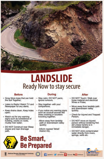
Answer:
Do it yourself.
Question 15.
Divide the class into three groups. Each group will work on one project (water, wind, and glacier). The project should highlight the causes, impact on human life and the environment, and mitigation measures.
Answer:
Group 1: Water (River and Coastal Processes)
Project Title: Water as an Agent of Landform Formation and Disasters
Causes
- Heavy rainfall and floods
- Fast-flowing rivers
- Sea waves and ocean currents
- River erosion and deposition
- Human activities such as deforestation and unplanned construction
Impact on Human Life
- Floods damage houses, roads, and bridges.
- Loss of lives, crops, and livestock.
- Displacement of people from affected areas.
- Spread of water-borne diseases.
- Damage to transport and communication.
Impact on the Environment
- Soil erosion and loss of fertile land.
- Changes in river courses.
- Destruction of forests and wildlife habitats.
- Siltation of rivers and reservoirs.
- Coastal erosion and loss of beaches.
Mitigation Measures
- Plant trees to reduce soil erosion.
- Construct embankments and check dams.
- Improve drainage systems.
- Avoid construction in flood-prone areas.
- Promote rainwater harvesting and watershed management.
- Create awareness about flood safety.
Group 2: Wind
Project Title: Wind as an Agent of Erosion and Deposition
Causes
- Strong winds in desert and semi-arid regions.
- Drought and low rainfall.
- Loose, dry soil.
- Deforestation and overgrazing.
- Climate change and rising temperatures.
Impact on Human Life
- Dust storms reduce visibility and affect transport.
- Respiratory problems due to dust.
- Damage to crops and property.
- Disruption of daily life and economic activities.
Impact on the Environment
- Loss of fertile topsoil.
- Desertification.
- Damage to vegetation.
- Formation of dunes and deflation hollows.
- Reduced agricultural productivity.
Mitigation Measures
- Plant shelter belts and windbreaks.
- Increase vegetation cover.
- Prevent overgrazing.
- Practice sustainable farming.
- Conserve soil through afforestation.
- Use weather forecasts for early warnings.
Group 3: Glacier
Project Title: Glaciers: Landforms, Hazards, and Conservation
Causes:
- Slow movement of glaciers.
- Climate change and global warming.
- Rapid melting of glaciers.
- Formation of glacial lakes.
- Heavy snowfall and avalanches.
Impact on Human Life
- Glacial Lake Outburst Floods (GLOFs) damage villages and roads.
- Avalanches threaten people in mountain regions.
- Disruption of hydropower projects.
- Loss of life and property.
- Reduced freshwater availability in the future.
Impact on the Environment
- Destruction of mountain ecosystems.
- River flooding.
- Habitat loss for alpine plants and animals.
- Increased landslides.
- Changes in river flow patterns.
Mitigation Measures
- Monitor glaciers and glacial lakes regularly.
- Install early warning systems.
- Restrict construction in high-risk areas.
- Promote afforestation in mountain regions.
- Reduce greenhouse gas emissions.
- Prepare disaster management and evacuation plans.
Conclusion:
All three agents—water, wind, and glaciers—play an important role in shaping the Earth’s surface. However, they can also cause natural disasters. Proper planning, environmental conservation, and public awareness can help reduce their harmful effects while allowing people to benefit from these natural processes.